.jpg)
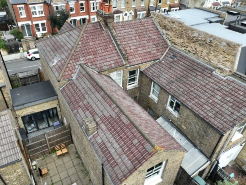
Yorkshire Housing were advised to undertake a full roof replacement costing c. £350k. Vantage UAV's drone inspection & 3D model revealed only c. £50k of work was required - an 85.7% cost saving!

The UK's national infrastructure – from rail networks and utilities to communication systems and roads – requires continuous monitoring and maintenance to ensure safety and operational efficiency. Traditional inspection methods often involve significant risks, operational disruption and substantial costs. Vantage UAV's advanced drone technology provides the solution. Our services deliver speed and efficiency for detailed asset inspections while eliminating access challenges and reducing risk.

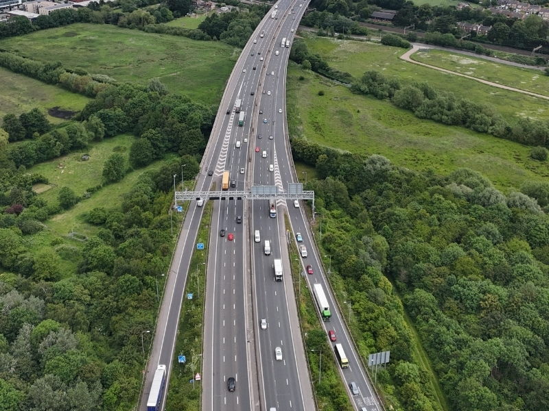
Comprehensive highway surveys utilise high-resolution 4K cameras and multispectral imaging to assess barriers, signage, lighting systems and drainage infrastructure without disrupting traffic flow. Advanced photogrammetry creates detailed visual information to assess condition and safety.
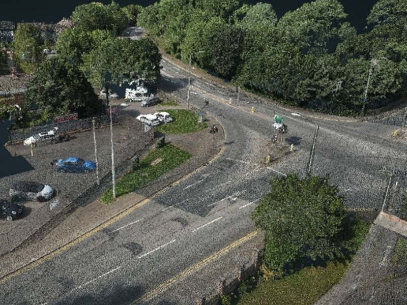
Monitor road features including road lines, reflective road studs, cracks and surface conditions to support planned maintenance and avoid accidents from poor surfaces. GPS-referenced mapping provides exact locations for maintenance teams, eliminating time-consuming manual searches.
High-resolution aerial imagery combined with LiDAR identifies road surface defects, cracking patterns and areas requiring maintenance intervention without traffic disruption. Aerial photogrammetry provides detailed surface visual data that when combined with LiDAR allows precise measurements of pavement deformation, rutting and surface irregularities to be identified.
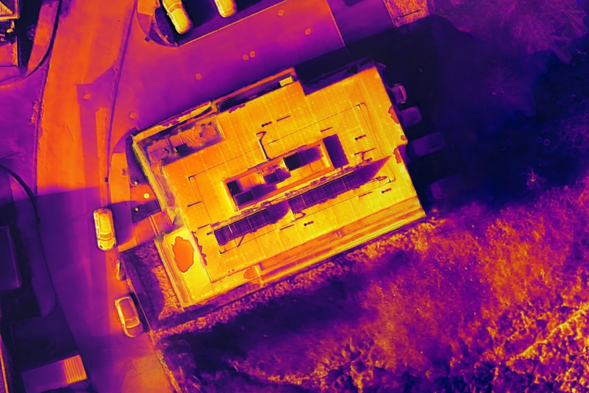
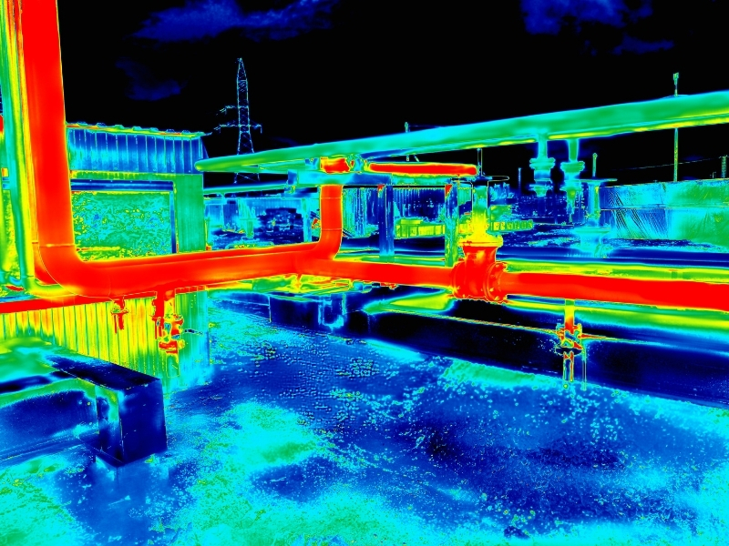
Thermal imaging reveals subsurface moisture issues and structural weaknesses not visible to the naked eye. Multispectral analysis identifies different pavement materials and assesses surface condition variations across large road networks. This data can be inspected from a desk to quickly classify crack types, assess severity and prioritise maintenance interventions.
Bridge assessments evaluate deck condition, support structures and expansion joints without lane closures or expensive access equipment. High-resolution cameras with advanced zoom capture detailed imagery of structural elements, identifying corrosion, cracking and deterioration. Thermal imaging reveals moisture ingress, delamination and structural defects not detectable through visual inspection alone.
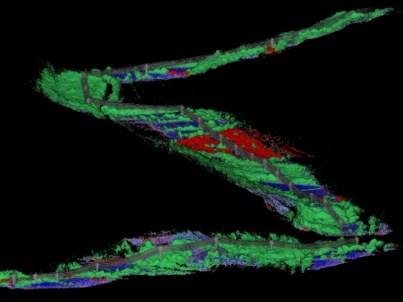
LiDAR technology creates precise 3D point cloud models of bridge geometry enabling accurate measurement of structural compliance with load-bearing specifications. During load testing, LiDAR precisely measures deflections to identify deformation and potential damage, verifying a bridge's weight-bearing capacity and overall structural health.
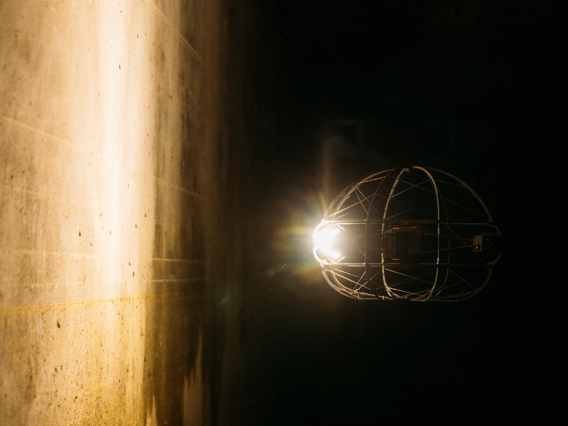
Specialised caged drones enable safe inspections of confined spaces under bridges and within bridge structures, accessing areas that traditional inspection methods cannot safely or efficiently reach. This integrated approach eliminates the need for scaffolding, cherry pickers or rope access teams, significantly reducing inspection costs whilst delivering superior data quality.
Construction progress monitoring utilises aerial surveys to document project advancement and verify contractor performance against schedules. Stockpile volume calculations provide accurate measurements of materials on site, supporting inventory management and billing verification.
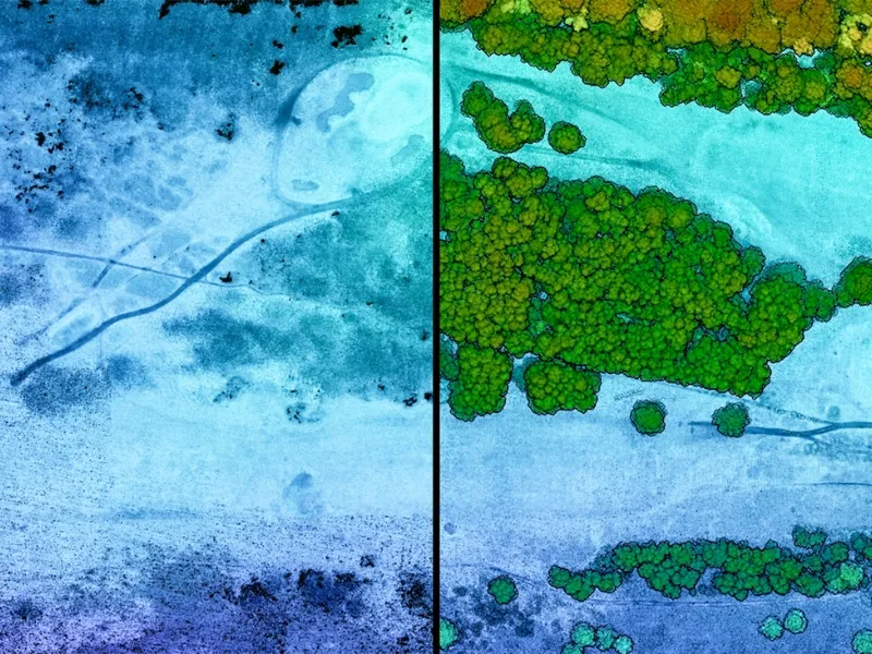
Land surveys and orthomosaics deliver detailed mapping data for project planning and design verification. Terrain LiDAR modelling data identifies ground conditions, vegetation types requiring clearance and hidden terrain features that could impact construction activities, enabling accurate project planning and cost estimation.
HHLA Sky’s drone control centre enables multiple aircrafts to perform different tasks simultaneously across large construction sites, including progress monitoring, stockpile surveys and safety inspections, significantly improving efficiency and data collection capabilities.
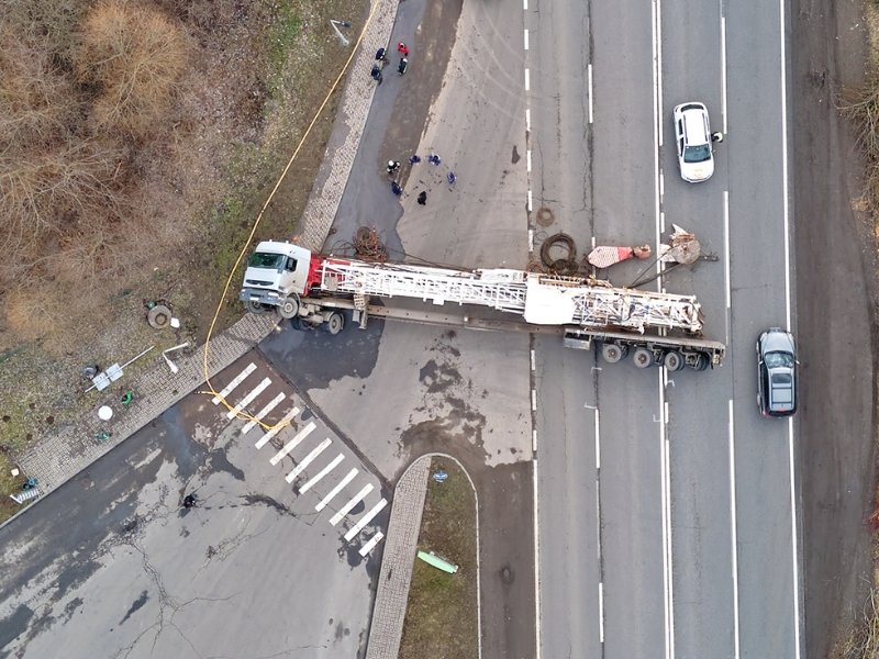
Rapid structural damage assessments following accidents or failures provide critical information for emergency response planning and public safety decisions. Accident investigation surveys capture comprehensive scene documentation, creating detailed 3D models for analysis and reconstruction.
Such data provides supporting evidence for insurance claims, while incident data informs future decision-making regarding road design modifications and structural improvements to enhance safety.

Comprehensive highway surveys utilise high-resolution 4K cameras and multispectral imaging to assess barriers, signage, lighting systems and drainage infrastructure without disrupting traffic flow. Advanced photogrammetry creates detailed visual information to assess condition and safety.
Monitor road features including road lines, reflective road studs, cracks and surface conditions to support planned maintenance and avoid accidents from poor surfaces. GPS-referenced mapping provides exact locations for maintenance teams, eliminating time-consuming manual searches.
High-resolution aerial imagery combined with LiDAR identifies road surface defects, cracking patterns and areas requiring maintenance intervention without traffic disruption. Aerial photogrammetry provides detailed surface visual data that when combined with LiDAR allows precise measurements of pavement deformation, rutting and surface irregularities to be identified.
Thermal imaging reveals subsurface moisture issues and structural weaknesses not visible to the naked eye. Multispectral analysis identifies different pavement materials and assesses surface condition variations across large road networks. This data can be inspected from a desk to quickly classify crack types, assess severity and prioritise maintenance interventions.
Bridge assessments evaluate deck condition, support structures and expansion joints without lane closures or expensive access equipment. High-resolution cameras with advanced zoom capture detailed imagery of structural elements, identifying corrosion, cracking and deterioration. Thermal imaging reveals moisture ingress, delamination and structural defects not detectable through visual inspection alone.
LiDAR technology creates precise 3D point cloud models of bridge geometry enabling accurate measurement of structural compliance with load-bearing specifications. During load testing, LiDAR precisely measures deflections to identify deformation and potential damage, verifying a bridge's weight-bearing capacity and overall structural health.
Specialised caged drones enable safe inspections of confined spaces under bridges and within bridge structures, accessing areas that traditional inspection methods cannot safely or efficiently reach. This integrated approach eliminates the need for scaffolding, cherry pickers or rope access teams, significantly reducing inspection costs whilst delivering superior data quality.
Comprehensive highway surveys utilise high-resolution 4K cameras and multispectral imaging to assess barriers, signage, lighting systems and drainage infrastructure without disrupting traffic flow. Advanced photogrammetry creates detailed visual information to assess condition and safety.
Monitor road features including road lines, reflective road studs, cracks and surface conditions to support planned maintenance and avoid accidents from poor surfaces. GPS-referenced mapping provides exact locations for maintenance teams, eliminating time-consuming manual searches.


We're here to answer any questions you may have.
.jpg)