autel logo
We are proud to announce that we are now the official UK Repair and Maintenance Centre for Autel!
Click to find out more
autel logo
CASE STUDY
LiDAR
Client:

Power Line & Substation LiDAR Inspection.

Overview

blue triangle svg icon
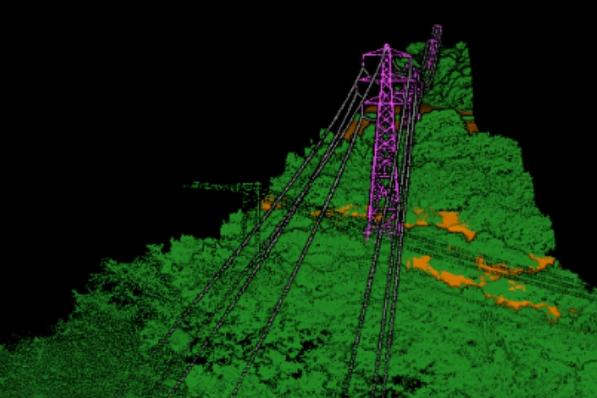
Vantage UAV captured high-resolution LiDAR dataset across ~20km of powerlines, towers and substations for a National Grid subcontractor operating in challenging rural terrain.
blue triangle svg icon
Produced a complete 3D model to support vegetation analysis, line sag/movement modelling and long-term maintenance planning.
blue triangle svg icon
Completed in two days using the DJI Matrice 300 + YellowScan Surveyor Ultra LiDAR system, delivering a fully colourised, classified and geo-referenced point cloud at very high density and sub-3cm accuracy.
St Luke's Church
drone in flight

The Problem

The client maintains National Grid transmission infrastructure, including overhead lines, towers and substations across remote, difficult terrain. Traditional “walk-the-line” inspections were slow, costly and sometimes unsafe, limiting inspection frequency and making it hard to capture consistent, complete corridor data.

They needed a safer, faster way to model line movement, assess vegetation clearance and growth risk, capture accurate terrain, tower & conductor geometry and support long-term maintenance and upgrade planning.

If left unchanged, the existing approach would continue to expose teams to safety risks, increase operational cost and limit the quality and completeness of the engineering data available for critical network planning.

Improved Safety

Faster Delivery

Higher-Quality Engineering Insight

The Solution

Vantage UAV delivered a full corridor LiDAR mapping survey across ~20km of live transmission infrastructure, capturing towers, conductors, substations and surrounding terrain to create a consistent, engineering-grade 3D dataset. Each section was flown with a 50m stand-off distance to reduce risk while maintaining extremely high data quality, with on-site verification using YellowScan CloudStation to ensure complete coverage before leaving each location.

  • Data was captured over two days using a DJI Matrice 300 equipped with a YellowScan Surveyor Ultra LiDAR sensor, supported by on-site GNSS base stations tied to existing control and Ordnance Survey permanent stations.

  • A fully colourised, classified, geo-referenced point cloud delivered at ~1300 points/m² and <30mm RMSE against control across the full corridor.

The on-site quality control (QC) removed the risk of data gaps and avoided return visits. Post-processing using Applanix POSPac refined the trajectory and geo-referencing, before final classification and colourisation of the dataset.

3D model of church
3D model of church

Conclusion

Vantage UAV completed the survey across remote, difficult terrain and a long linear corridor, where access is often slow, complex and high-risk. The work was delivered safely around live transmission infrastructure and it was completed within a tight operational window without compromising data quality or corridor-wide consistency.

The resulting dataset supports a shift from visual inspection to full 3D, data-driven asset management. It is ready for automated vectorisation, tower, conductor and vegetation modelling and detailed clearance analysis with growth simulation to support proactive maintenance planning.

  • Improved Safety - Stand-off flight methodology reduced exposure around live transmission assets and difficult terrain.

  • Faster Delivery - Corridor data captured in two days, reducing time on site and accelerating access to usable outputs.

  • Higher-Quality Engineering Insight - High-density, geo-referenced LiDAR enabled accurate modelling of line sag, clearance and vegetation risk.

  • No Repeat Visits - On-site QC minimised rework and prevented gaps that typically trigger costly return surveys.
Faster Delivery
Corridor data captured in two days, reducing time on site and accelerating access to usable outputs.
Higher-Quality Engineering Insight
High-density, geo-referenced LiDAR enabled accurate modelling of line sag, clearance and vegetation risk.
Improved Safety
Stand-off flight methodology reduced exposure around live transmission assets and difficult terrain.
No Repeat Visits
On-site QC minimised rework and prevented gaps that typically trigger costly return surveys.
References / Sources:
All imagery / information within this case study is used with the express permission of:

Get In Touch

Do you need help in unlocking the cost-saving power of drones for your business?

Or call:
0203 871 8226